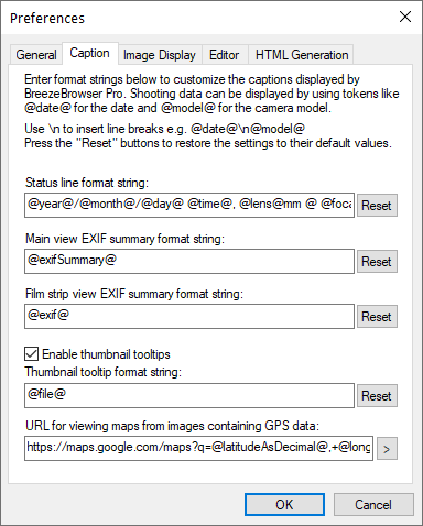
The EXIF summary displayed in the status bar at the bottom of the screen can be customized by editing the status line format string. This format string uses the same tokens to specify the settings to be displayed as the HTML generator (see HTML Generation). Pressing the "Reset" button will restore the string to the system default which is:
"@year@/@month@/@day@ @time@, @lens@mm @ @focalLength@mm, @shutter@sec f/@aperture@, Exp:@exposureMode@, ISO @iso@, AF:@focusMode@, WB:@whiteBalance@, Flash:@flash@"
Please note that Windows can only display the first 128 characters in the status line.
The main view EXIF summary (displayed on the right hand side of the main view window when "Show controls" is enabled) may be customized by editing the format string. The default value is "@exifSummary@".
New lines can be entered using "\n" e.g. use the following format string to add separate lines with the camera model name and IPTC copyright field to the EXIF summary:
"@model@\nCopyright: @IPTC_copyight@\n@exifSummary@"
The filmstrip view EXIF summary may be customized by editing the format string. The default value is "@exif@"
Select "Enable thumbnail tooltips" to display a popup window showing shooting data when the mouse hovers over thumbnails in the thumbnail and filmstrip views. The shooting data that is displayed may be customized by editing the format string. The default value is "@file@"
Use "\n" to break up the tooltip text into multiple lines
e.g. "@model@\n@shutter@sec, f/@aperture@\nISO @iso@\n@lens@mm @ @focalLength@mm"
The locations where images containing GPS data were taken can be displayed in a web browser by right clicking on the image in BreezeBrowser Pro's main view and selecting "View map".
The URL used for viewing the map is user definable and defaults to Google maps:
http://maps.google.com/maps?q=@latitudeAsDecimal@,+@longitudeAsDecimal@
The following URL displays GPS location in Google Maps zoomed in to zoom level 15:
http://maps.google.com/maps?q=@latitudeAsDecimal@,+@longitudeAsDecimal@&z=15
The following URL can be used to link to Microsoft Live Search Maps zoomed in to level 14:
http://maps.live.com/default.aspx?cp=@latitudeAsDecimal@~@longitudeAsDecimal@&lvl=14&style=r&v=2
The following URL can be used to link to Yahoo! Maps zoomed in to magnification 3:
http://maps.yahoo.com/index.php#lon=@longitudeAsDecimal@&lat=@latitudeAsDecimal@&mag=3
Click on the ">" button to select different preset map URLs.
The "View map" menu option can be disabled by setting the URL to an empty string.
Other Map URLs
Topographic maps in the US can be displayed using the URL:
http://www.topozone.com/map.asp?lat=@latitudeAsDecimal@&lon=@longitudeAsDecimal@&datum=NAD83&u=5&layer=DRG&size=l&s=24